We are at Bachsten Bush Camp at the southern end of Prince Regent National Park. Came in with the owners to help open the Munja Track in a convoy of a tractor and three vehicles. It took three days to get here and had to get towed out of a bog twice. It's too wet to open the track the rest of the way.
Will have a good look around while we wait for the track to dry out enough to get out by ourselves. Expect to be here for at least a week, more if it rains.
Wednesday, May 29, 2013
Munja Track and Bachsten Bush Camp
29 May - Again, an update from Canberra. I've added some links for those who are interested in the kind of thing they're up to or seeing, but no new photos from the folks for now.
Monday, May 27, 2013
24 May - Water, water, planes and falls
Ok, so this is submitted on behalf of the folks who are too busy exploring but able to shoot off messages from their new sat phone on occasion just to keep the rest of us jealous. Check out the map for location and the pictures to give you the gist of how they're spending their days.
24 May
Not able to make it to Kalumburu due to heavy rain having closed the road indefinitely.
Had two nights at the Drysdale River station and did some canoeing. Took a two hour flight over the Prince Regent River, King Cascade Falls, Mt Trafalgar and Mitchell Falls. It was fantastic!
Have now headed west to Mount Elizabeth Station. Disappointed to miss the north.
Saturday, May 18, 2013
waiting for sunset at home valley station.
magnificent country up here.
yesterday we went to Emma Gorge on El Questro. Did the hike to the top and had a lovely swim in the pool at the base of the waterfall. Staying at home valley station. they have a magnificent swimming pool and good camping. have been looking around the station today.we are waiting for the sunset in the rain, hoping the clouds will lift. on top of a hill, so ee have mobile coverage.
back to el questro tomorrow for 3 nights.

Thursday, May 16, 2013
Off into the wilderness
Heading to El Questro tomorrow, then along the Gibb River road, and up to Kalumburu, visiting sights along the way. Then back to the Gibb River road to continue westwards.
Don't expect any updates until we emerge into mobile phone contact again
Kununurra
Yesterday we drove to Wyndham via Valentine springs and Parry's lagoon, along the western bank of the ord river. Lots of birds. Found a grassy patch with lots of kangaroos. Haven't seen many on this trip. Saw the barra in the river, but no crocs, just evidence that they had been around.
Peter had barra for lunch in Wyndham. Magnificent view from the lookout, new community wharves at the port. Discovered we had a leak in our water tank, so Peter has been under the car locating that, and is now emptying the tank, so he can repair it tomorrow.
Picked up our new sat phone this afternoon. It will be good to have it in case of emergencies.
Today we have been shopping, then packing up the car. Time to leave this town!!!!!
Tuesday, May 14, 2013
Timber Creek to Kununurra
Headed west along the highway past the Gregory tree.
Just before the border we stopped at Zebra Rock mine, which had been recommended to us in Alice. They mine zebra rock there, do boat trips, and have camping. And serve scones, jam and cream!!!!
Did the afternoon wetland cruise, heaps of birds, like a yellow waters cruise in kakadu. Also saw a few freshwater crocs. The boat then stopped for a swim and sunset with drinks and nibbles, before returning home.
Peter had Silver Cobbler fish and chips, and really enjoyed it. Silver cobbler is a catfish, renamed to make it more palatable. Of the 3 varieties of catfish it reputedly the only one that is good to eat.
We needed some food and a washing machine, so we headed into Kununurra. It was Saturday morning, and the town was really busy. Had fantastic frozen mango from the market, did a bit of shopping and headed out again, back to Lake Argyll.
Stayed in the resort out there (camping of course) and swam in their infinity pool, which had a backdrop of Lake Argyll. Magnificent views. There was a wedding there, and their photos would have been simply awesome, with the lake as background.
We backtracked again to Keep River National Park where we camped, then did an 8 km walk in the early morning. The formations are similar to the Bungle Bungles. Very impressive. It rained a little overnight, so at 3 am there was a mad scramble to put the fly on the tent.
We are now in Kununurra, where it is quite windy, and we are cool for the first time in the daytime. It is mid 20s this morning, but expected to heat up in the afternoon.
During our travels we have felt very remote most of the time. We heard from other travellers that there is a 50% rebate on satellite phones for remote travellers, so we applied for one yesterday. hoping for approval in a couple of days. Hopefully we will not have to use it, but we will have it anyway. From now on all we expect to see is the odd Telstra phone box, or pay a fortune to the stations to use their satellite internet. We don't plan to use it for long chats, and apparently they are very expensive to ring.
We will see the sights of Kununurra, and stock up on provisions.


Top Springs to Timber Creek.
We continued along the buchanan highway heading west, with plans to go along the Binns track through Gregory National Park.
We had not done enough homework. We headed along the Binns for 50 km ( off the Buchanan), past an aboriginal town, through about a.dozen gates to find a Road Closed sign on the track near Humbert.River station. Back we went.
However, it did turn out to be my lucky day. At the second gate on the return trip, Peter saw my mobile phone sitting in the dirt. I am so pleased i have a bright blue cover on my phone. it must have fallen out of my pocket on the way in.

Back onthe Buchanan, we drove through the pretty Jasper Gorge.


Just after this there was a 4wd track into Gregory National Park, but the info said it took 3 hours and it was already 4pm, so we drove up the main road to Timber Creek.
The next day we headed into gregory again.
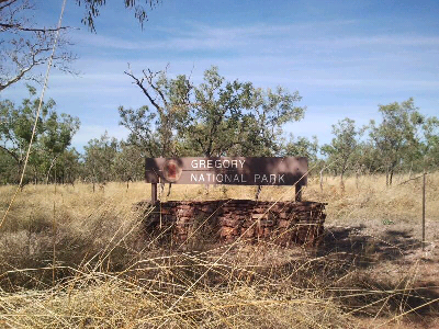
This time there were signs telling us almost everything was closed. We did a walk at the calcite flows on limestone creek, but the road was closed 2 km before the campground.
Continued south to Bulitta, went through the old homestead. The info said you could camp there and go to the river to catch your dinner. But, there was so much growth along the river, you couldn't get close.
Hot (above 35°) and cranky, we returned to Timber Creek. Spoke to the ranger who said gregory was always the last park to open after the wet, and was a couple of weeks away from being fully open.
Alice to Top Springs
had a couple of lazy days in Alice, then headed north through the tropic of Capricorn

and the Devil's marbles

Refuelled in Tennant Creek, then stopped overnight at Banka Banka station. Our neighbours in caravan park in Alice had recommended it. They are doing a roaring trade. Definitely the popular place to stay, well away from any town.
We continued on up the Stuart Highway to Daly Waters pub

for a lunch of barra bites and chips.

decided not to go on the helicopter ride.

We then backtracked 30 km to the Buchanan highway, and headed west.
Anthills started to appear

and we did our first river crossing

and rewarded ourselves with bread and jam and cream!!!!

Stayed at Top Springs behind the pub. later that night a nt government prado came in on 3 tyres and a rim. They had driven 30km when their second spare blew.
17" tyres were non existent in top springs, so they had a long wait for help from Katherine
Sunday, May 5, 2013
week 2 plans - alice to kunnunurra
leave Alice on monday morning. Change of route from original plan. Now coming home down the Tanami.
heading north to Tennant Creek, Daly Waters for a drink, then west along Buchanan highway ( now part of Binns track) to Gregory National park.
Then on to Timber Creek and Kunnunurra.
Friday, May 3, 2013
Coober Pedy to Alice Springs
We are in fly country, so the hats and fly nets are out. Flies get up with the sun and go to bed at sundown, so there is a small window of light between dawn and sunrise to eat breakfast.
road from coober pedy to oodnadatta

afl ladder in pub at oodnadatta

travelled from oodnadatta to dalhousie springs via perdika bore road. Road not too bad to Perdika Bore, but after that it was atrocious, 20km per hour. camped at Dalhousie. Peter left his car floor mat (which he used to stand on
to get dressed) outside the car at night, and the DINGO took it. He hopes it tasted good.
The springs at Dalhousie are wonderful, so had a long hot swim (approx 38 degrees). also several more before leaving next day.
In the morning we did the 6 km walk to Kingfisher springs, a mound spring in the park. nice clear water, but overgrown and only one acccess point. good fitness training for us.
After lunch we headed for Mt Dare hotel, a favourite camping spot. Road very slow and rocky. national parks must have no money for road maintenance.
From Dalhousie we headed north along the Binns track to Old Andado. Beautiful country in national park to the border

sa nt border
then opened up into grazing land which was quite heavily treed. We took it slowly and cattle were the only wildlife we saw.

At Old Andado wandered around the historic buildings


before heading north down the swales(valleys) between the low sandhills to Mac Clark conservation park.
very old acacia peuce (waddy) trees, up to 700 years old. very rare now, and fenced to protect the from the cattle. The conservation park is north simpson desert, and very bare and rocky, just the sparse trees.


we camped at mac clark, the wind howled and the flies were still thick. no mossies though cos no water.
Very isolated, we saw 1 car today.
After an early rise, we headed into Alice,through the Rodinga Range. Nice hills, pretty countryside, road improving.
Drove through Santa Teresa aboriginal area. It is a dry area, so a
the drinking is done just outside, and cans and bottles strewn everywhere. Especially on the Alice side, you have to finish your grog before you get home.
Arrived in Alice Springs mid afternoon, and have settled into a caravan park and are camping on green grass.
Subscribe to:
Posts (Atom)